 NCRPC was awarded a FY 2022 US Department of Transportation SMART Grant for a project titled “Smart Counties in Kansas.” The project aimed to leverage the use of innovative aviation technology. The project proposed to prototype the use of drone technology for transportation asset monitoring in concert with a GIS-based platform that integrates local infrastructure assets. The goal of this project was to provide innovative data monitoring of asset conditions and inform technical solutions for rural infrastructure management in Kansas.
Summary
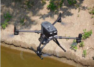
NCRPC launched the SMART Project to introduce governments to advanced information-gathering technologies—such as Geographic Information Systems (GIS), UAS drones, and remote sensing tools—and to demonstrate their practical application in managing and inspecting road and bridge networks. Bridges were selected as the primary demonstration focus, although the project acknowledged a broader range of potential uses. Four counties participated, with support from technical experts.
The project had four key components:
- GIS Platform Development
- UAS Drone & Remote Sensing
- Computer Modeling
- Workforce Training & Tools
View the full Project Summary (PDF, 62 KB)
StoryMap
Smart Counties in Kansas – Drones, Data & Better Bridges
Want to learn more? Click the link above to explore the ArcGIS StoryMap and learn how four Kansas counties and NCRPC are using USDOT’s SMART grant to enhance infrastructure safety, fairness, and future-readiness
Resources
Production of these videos was made possible by a 2022 Strengthening Mobility and Revolutionizing Transportation (SMART) grant awarded the NCRPC by the U.S. Department of Transportation.
The following informational videos illustrate how best to pilot a UAS drone under specific conditions as well as explain the best uses of conventional photography, thermal imaging, photogrammetry, and LiDAR technologies when those are applied to bridge and road inspections.